The project was built in Spotlight Property Viewer to simplify the preconstruction sales process.
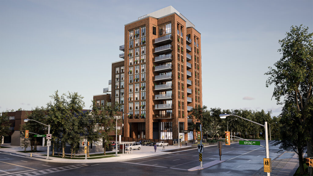
3D CityScapes is proud to present Spotlight Property Viewer, its custom visualization platform solution for preconstruction developments. The software debuted in conjunction with the Elegance, a 72-unit luxury condominium in Vaughn, Ont. and developed by Avalee Homes.
One part marketing tool, one part sales asset management system, the Avalee Homes team selected Spotlight Property Viewer given that the Elegance was their first solo residential development and wanted a 3D visualization application backed by an experienced team.

“You can see multiple points of view, different suites, and floors. The actual colours are more true than just a model that sits on a table. It gives you more of a feeling of the building than a [traditional] model,” said Lino Tatone, one of Avalee’s founders.”It’s going in a more digital way so it’s more in tune with the times.”
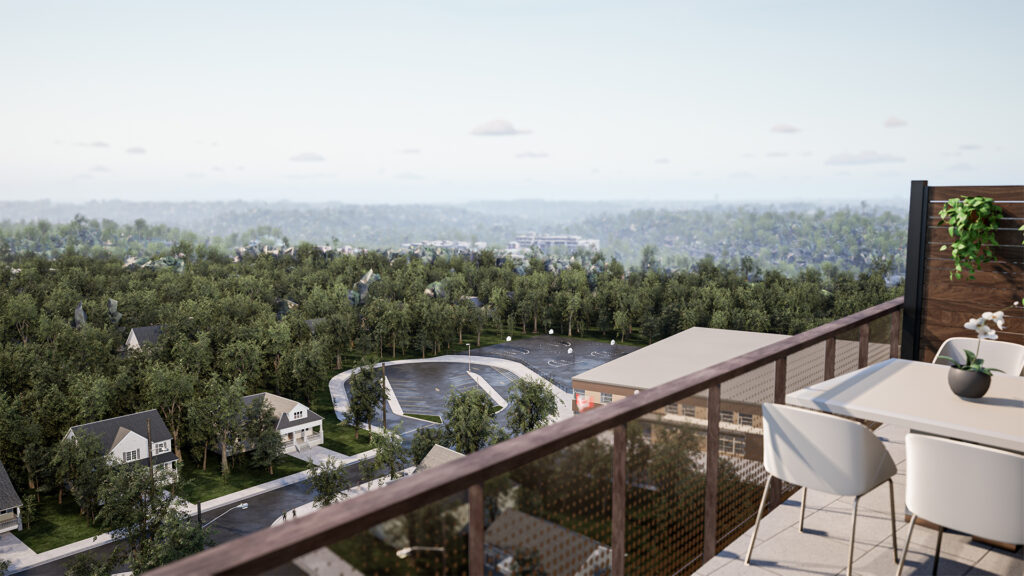
In addition to providing an immersive 360-degree view of the Elegance’s exterior and the surrounding area, Spotlight Property Viewer allowed the sales team to take customers inside the upcoming development, highlighting specifics like the interior views of the penthouse unit, the front-entrance lobby, and even give a sneak peek at the views from the terraces.

“I personally like the daylight-night time [function] so you could see what it was like during the day or night. The biggest thing was the views from certain parts of the building, the location of the building, seeing the building itself, the way it looks, the terraces, and the walk-through,” said Tatone. “The walk-through helps with the amenities and the 3D application helps you get a real feel for the amenities and the outsides, too.”

Additional features also provided with Spotlight Property Viewer include:
-A walkable avatar mode to simulate a first-person point of view perspective of the building and area
-A unit selector to compare, contrast, and filter units based on square footage, pricing, number of bedrooms, bathrooms, and or orientation
-The ability to compare multiple floor plans side by side
-Distance circles to highlight what’s walkable within five, 10, and 20-minute increments.
-Finish selector to give customers the ability to swap between builders’ fit and finish packages.
-A built-in render generator to provide picture-perfect images for social media and marketing purposes
For 3D CityScapes, Spotlight Property Viewer represents the culmination of four years of work in the prop-tech industry, combining the company’s expertise in 3D modelling and meeting the needs of developers looking to showcase the best of what their projects have to offer.
“The Avalee team wanted to make sure the application represented luxury and that’s something that we did. They were very conscious and aware that they wanted to make this thing look great. And that really helped us achieve our goal,” said James Borst, CEO and founder of 3D CityScapes. “This application became basically our flagship for small developments. I’d say it’s our highest-quality development to date.”
About 3D CityScapes:
3D City Scapes Inc. is a 3D visualization technology company based in Canada specializing in building 3D interactive environments, assets, and digital twins. Founded in 2019, 3D CityScapes works with property developers, municipalities, urban planners, seaport authorities, and architects to provide 3D applications for use in sales/marketing, planning, predictive analysis, cinematic video production, and more.
-30-
For more information, please contact:
Brian Tien Trinh
3D CityScapes
647-524-4003
Btrinh@3dcityscapes.ca

What began as a drawing on a napkin is now an interactive 3D application.
It’s a whole new ballgame for the team at 3D CityScapes following the delivery of its first-ever virtual application of a sports training facility in conjunction with the team at Prospect Dome.
Located in Toronto’s Rexdale neighbourhood, Prospect Dome is a proposed year-round indoor and outdoor training facility for young athletes looking to compete in baseball, soccer, basketball, and lacrosse.
For its part, 3D CityScapes delivered a standalone application that provides a virtual walkable tour of the proposed facilities’ exterior and interior amenities. The project not only highlighted the team’s skills in 3D visualizations but also its in-house creative conceptual offerings for clients needing help when it comes to the design component of projects.
What began as a rough sketch is now a fleshed-out 3D visual tool perfect for fundraising or marketing purposes, says James Borst, 3D CityScapes’ CEO and Founder.
“This was an exciting project for us. The team had a lot of fun because there was a lot of creative liberty for the overall design of the building’s exterior and interior,” said Borst. “We were given a drawing on a napkin – a very basic outline of the project such as the different rooms that are going to be there.”
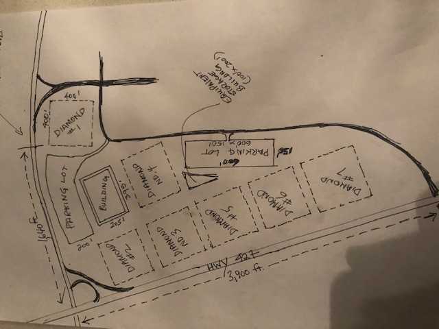
From there, the team created a way to virtually explore upcoming areas like the facility’s 12 batting cages, rooms for physiotherapy and training, as well as five outdoor enclosed “bubble” fields for practice or tournaments.
What’s more, the team provided the Prospect Dome team with a fly-through video and multiple hot-spot tours highlighting common areas, complete with animated Metahumans powered by the Unreal Engine.
“Our tool is directly being utilized to help get this project off the ground, which is an awesome utilization of our technology,” said Borst. “It’s something that warrants having a 3D interact environment to showcase the power, innovation, and excitement of the project coming to the community.”
About 3D CityScapes:
3D City Scapes Inc. is a 3D visualization technology company based in Canada specializing in building 3D interactive environments, assets, and digital twins. Founded in 2019, 3D CityScapes works with property developers, municipalities, urban planners, seaport authorities, and architects to provide 3D applications for use in sales/marketing, planning, predictive analysis, cinematic video production, and more.
-30-
For more information, please contact:
Brian Tien Trinh
3D CityScapes
647-524-4003
Btrinh@3dcityscapes.ca
3D CityScapes got its start with McMaster Innovation Factory’s help.

March 30, 2022
Toronto – It’s come full circle with 3D CityScapes (3DCS), a Canadian leader in 3D visualization, thanks to its recently completed partnership with McMaster Innovation Park (MIP).
3DCS is proud to offer a look at its 3D model of MIP, a 58-plus acre park supporting startups, multinational businesses, incubators, and accelerators, giving a glimpse of what the future has in store for the park and the Greater Hamilton Region.
“Innovation is at the heart of MIP and we are extremely pleased when we get to engage in projects that allow us to share the extraordinary vision of our master plan. 3D CityScapes’ ability to bring that to life is an added benefit to our initiatives and we are really excited to work with such a talented team,” said Scott Rasmussen, Vice President of Leasing & Business Development at MIP.
For 3DCS, it marks a return to its roots in Hamilton, Ont. as the company got its start in conjunction with McMaster Innovation Factory as well as IBM Venture Labs in Markham, Ont..
“We wouldn’t be here if it weren’t for these transformative spaces where innovative ideas and vision come to reality,” said Raza Jafri, 3DCS’ Co-Founder & Vice-Chairman of the Board. “MIP offers companies a place and a launchpad to grow and to scale and access world-class talent in a region of Canada that’s quickly becoming well-known not just in Canada but all over North America as a central innovation hub.”

As part of this partnership, 3DCS will continue to digitally support MIP with its adaptive 3D visualization technology as the park grows and expands.
“That personal bond we have with MIP is unshakable and we know as we scale this into other projects and we grow together, we’ve built a working relationship where they know completely who we are, we understand their needs and requirements and it’s a synergy like no other,” said Salman Hussain, 3DCS’ director of digital experiences.
“We’re excited for the future. We’re building out so it’s not just a one-time project, it’s something that will continue to grow as MIP gets through the different phases that we need to do more, build more, and get designs out there that will tell people what we’re doing at MIP,” said Shauna-Kay Williams, MIP’s marketing & communication manager.
About 3D CityScapes:
3D City Scapes Inc. is a 3D visualization technology company based in Canada specializing in building 3D interactive environments, assets, and digital twins. Founded in 2019, 3D CityScapes works with property developers, municipalities, urban planners, seaport authorities, and architects to provide 3D applications for use in sales/marketing, planning, predictive analysis, cinematic video production, and more.
-30-
For more information, please contact:
Brian Tien Trinh
3D CityScapes
647-524-4003
Btrinh@3dcityscapes.ca
What 3D Viz Can (And Can’t) Do For Revitalizing Churches
Documenting vital information? Sure. Wooing critics of gentrification? Not so much.
You might have prayed in one, attended a wedding in another, and there’s a growing chance you might one day live in a church. Well, what used to be a church.
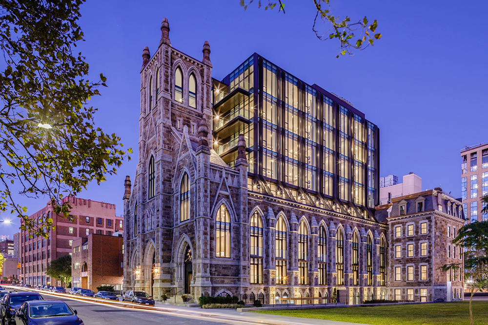
Converting old churches into condos is a growing trend among builders. The blend of old and new helps projects stand out against brand-new builds that rely on templated floor layouts. And that’s translating to faster sales, according to Ellen Anselone, a principal architect at Finegold Alexander, a Boston-based architecture firm.
Finegold Alexander specializes in revitalizing existing buildings. In 2017 it was tasked to transform an 1874 German Trinity Church in the city’s South End neighbourhood. The result was The Lucas, a boutique, eight-story condominium with 33 residences.
“There were already sold units when it started construction,” Anselone recalled. Keeping the facade also helped it compete with other new builds in the area, she added.
“The theory behind it was that there was a lot of new construction of condos and apartments going up right around the Lucas. But they were all cookie cutter. In the Lucas, because of the existing building, it couldn’t be cookie-cutter. You get to walk into the original church through that beautiful entry into your new building and it’s unique.”
Selling the idea of living in a converted church might have been easy but designing and building a structure within a structure came with obstacles to overcome. That’s where 3D visualization came into play. There are many types of tools out there but they typically fall into a handful of categories.
3D photogrammetry uses overlapping 2D photographs to extract an object’s height, width and depth. It’s good for smaller objects or wide swaths of land when the camera is mounted on a plane or drone.
3D sculpting uses non-destructive laser beams to capture the data of physical objects. That data is then uploaded and transformed into a 3D model.
3D visualized reconstruction is kind of like finishing a partially completed puzzle. There are pieces or structures still in place but some parts are missing due to destruction or centuries of wear and tear. To fill those gaps, modellers turn to archeological data, documents, research on the original builders as well as basic structural considerations to complete the rendering.
Finally, there’s building information modelling, or BIM. This process uses computer files to capture the building’s interior and exterior measurements. That includes width, height, depth, and sometimes their relationship to time and cost. Softwares like SketchUp and Revit help take that information and visualize it, according to Tony Hsiao, Finegold Alexander’s director of design and a fellow principal architect.

“From a design standpoint, we used a lot of 3D visualization tools. When you have an existing building, the interface of the new inserted into the old heavily relies on a lot of 3D masking studies, initial conceptualization, program fit, and of course as the design evolves, it gets further and further developed and fleshed out,” said Hsiao.
But the power of BIM isn’t just in visualization, it’s also about juggling large volumes of data, said Mikael Sydor, an architect, and senior project manager at ERA Architects Inc. in Toronto.
“Using BIM is a core part of our practice. We’re using it to manage information about the building including geometries, but also sort richer information – construction assemblies, phasing, looking at what era different parts of the building were constructed and what other information needs to be layered on there,” said Sydor. “So not just visualization but as an information management tool and archive tool.”
While Sydor hasn’t worked on converting churches into condos, he’s familiar with the intricacies that go into inserting a new building into an existing structure, pointing to his work with the Dentistry/Pharmacy Centre at the University of Alberta Campus in Edmonton as how it’s usually a mixture of different visualization techniques to get the job done.
“The Dentistry-Pharmacy [project] is surrounded by what we’re calling a 4D BIM model. It had the 3D geometry of the site that we based on laser scan information as well as archival drawings,” he said.
That 4th “D” refers to time, with the model incorporating time stamps from different information sources with tags denoting if a structural beam was modelled from archival drawing or if a plane was constructed through laser-scanning data.
This in turn helped communicate complex packs of information in an easier-to-understand format for other stakeholders, Sydor added. “It gave all of the project partners deeper information about the project, like where the information came from and where they’re able to make the most of it.”
MORE FROM 3D CITYSCAPES:
Property Technology Provides Answers, Leaves Realtors’ Future in Question
8 Cities Using Digital Twins to Help Residents
Metaverses vs. Digital Twins: Here are the differences between the two
That upside of BIM doubling as a communication tool also comes into play during the regulatory stages of revitalizing older buildings like the Lucas, said Anselone.
“Some of our more sophisticated clients are asking for 3D visualization and what we’re seeing is that it helps sell a project. And when I say ‘sell a project’, it helps it get through the permitting process because people can understand what you’re doing,” said Anselone. “If you give someone a set of drawings, they have no idea what they’re looking at. If you give them a 3D image, they get it.”

However, that power of instantaneous understanding varies depending on your audience. When it comes to community consultation on building revitalization, Hsiao prefers a softer approach to presenting ideas to locals who might be worried about gentrification.
“Sometimes the old school can help at the beginning,” he said, referring to his hand-drawn pencil sketches and watercolour paintings. “It’s a softer feel to it. More informal. Not so hard and not so finished and communities like that because of the room for interpretation. Sometimes these much looser, softer styles are very effective because it does provide people the feeling to talk with you. It doesn’t look locked
in. It’s a soft sell.”

Like Hsiao, a glossy 3D render only goes so far as to convert skeptics if you ask Sydo“Our approach towards working with the existing conditions and the existing buildings is understanding what parts of the structure, what parts of that building, represent what values the parties are engaged with,” said Sydor.
“It’s not necessarily about, ‘I’ve got this design and I need to show it off.’ It’s about a more nuanced understanding of the way people interact with these structures or buildings, more so than a glossy render.”
3D CityScapes is a Toronto start-up specializing in building digital twins and 3D visualizations. Interested in building a digital twin? Get in touch with us here or give us a shout at +1 416-477-6846
What’s Powering 3D CityScapes’ Digital Twins?
Unreal Engine, sensors, and a heck of a lotta data

In their simplest form, digital twins are virtual counterparts of real-world assets and processes that are connected by real-time data.
But what goes into building digital twins is a bit more complex. Over at 3D CityScapes, a Canadian tech startup specializing in building digital twins, the award-winning 3D visualization models are rendered in Unreal Engine by a team of seasoned developers and brought alive via real-time data integration.
Data (and lots of it)
What makes a digital twin different from any other 3D model is its integration with data sets. Any good model will offer a snapshot of an object at any given time. But by pairing it with a cloud-based system, digital twins are able to pull information from application programming interfaces (APIs) and display real-time conditions in and around an asset.
The result is a living, breathing interactive 3D rendering that visually communicates complex data to its users. This allows users to see, understand, and proactively use the data available to increase efficiency, reduce risks, and monitor the status of any given asset. And even if the data doesn’t exist (yet), digital twins allow for modelling of hypothetical scenarios. Now with the cloud-streaming features, end users can access the digital twin application from anywhere, on any device with an internet connection.
Sensors
Speaking of data, that’s largely collected by IoT (Internet of Things) sensors. At its core, IoT sensors are devices connected to the internet for easy collection, processing, and dissemination of information. 3D CityScapes doesn’t collect data itself but instead partners with groups like Sinay, a maritime data solutions company,to use their sensor networks. By teaming up, we’re able to visualize information like noise pollution, water contamination levels, and the movements of vessels and containers, adding a layer of value within our digital twins of smart seaports.

This partnership allows pockets of information that would usually sit siloed from each other to now be visualized together in a way that allows for predictive modelling, historical tracking, or real-time analysis.
A POWERFUL RENDERING ENGINE
3D CityScapes’ digital twins are distinct due to their photorealistic look. That’s thanks in part to the rendering software of choice, Unreal Engine 4. By using a proprietary mix of plug-ins, 3D CityScapes’ developers are able to use the engine to compile different images and data, and stitch them together in Unreal with ease and efficiency.
If you’re a gamer, there’s a good chance you’ve heard of Epic’s Unreal 4 as the engine powering games like Fortnite, Gears of War 5, or Kingdom Hearts 3. But the crossover from gaming to 3D visualization is more natural than you might think, according to David Weir-McCall, business development manager for architecture, engineering and construction at Epic.
“With digital twins, it’s really again about creating that thing people have been doing for many decades in the games industry, which is crafting a story,” said Weir-McCall.
He likens it to communicating large volumes of data that might be dense for anyone not from an architecture background through a visual medium.
“It’s what we like to call digital storytelling in a sense that we’re able to custom create your own user experience through your design or through your building.”
It certainly doesn’t hurt that the Unreal engine makes things easy on the eyes.
“New features like ray tracing and path tracing help add to the realism, giving our version of Unreal a long stride ahead of any other rendering system,” said Francesco Guido, 3D CityScapes’ lead developer. “With a large list of benefits like the engine being open-source, an extensive list of documentation, a huge community, and a great profiler for developers, it was the best choice to kick off all our new projects with.”
The results are digital twins that stand out for two reasons, for David Weir-McCall.
“There are a couple of aspects to them that are really unique for us. Firstly, the size and scale you guys are working with and then the level of fidelity that we see coming from you guys as well,” said Weir-McCall.
A TERRIFIC TEAM
Data and powerful visualization software are great items to have, but at the heart of it all, is 3D CityScapes’ team of developers who take the two and marry them together. Schedule a meeting with 3D CityScapes to start a conversation via the booking button below.
What industries do you think digital twins could have the most impact on?

Preventing the Next Shipping Container Cargo Crunch with 3D Imaging Tech
Visualization software can help smooth out kinks in supply chain management

If the shelves at your favourite stores are looking a little bare or you’re encountering sticker shock over your latest grocery bills then you’re not alone. A global supply chain crunch is making delivering imports tougher than usual and driving up costs of certain goods higher for anyone lucky enough to find what they need.
A perfect storm of COVID-19 outbreaks and labour shortages going back to the summer has resulted in shipping container delays and rising costs in major ports in the U.S. and China. Ningbo-Zhoushan Port, located south of Shanghai, shut down for two weeks in August 11 after a dock worker tested positive for COVID-19. It’s the world’s third-largest shipping container port with a volume of 27.5 million twenty-foot equivalent units (TEUs), according to Shipa Freight.
https://www.youtube.com/watch?v=YgAmtqr4A20
This is likely to be felt via rising prices and continuing shortages of certain goods, including in the Christmas trade.
In Southern California, a 73-boat backlog has popped up due to a lack of dock workers able to unload cargo containers. Cargo ships have been stuck outside the ports of Los Angeles and Long Beach for up to three weeks just to upload their goods, reports the Wall Street Journal. A lack of storage space has prompted shipping companies to jack up the prices, leaving shoppers footing the bill in the end.
“The terminal closures in China are leaving their mark and dampening the exchange of goods,” said Vincent Stamer, head of Kiel Trade Indicator, a German think tank.
“There are no signs of a sustained easing of the situation, which clouds the outlook for international trade. This is likely to be felt via rising prices and continuing shortages of certain goods, including in the Christmas trade.”
Exposing The ‘Frailty’ of the system
While cargo ship jams and closed ports are recent examples of the supply chain crunch, the root causes can be traced back to the early days of the pandemic, according to M. Johnny Rungtusanatham, the Canada Research Chair in Supply Chain Management and a professor at the Schulich School of Business at York University.
“The pandemic stifled demand for certain goods and as we are coming out of the pandemic, we’re seeing demand peak… a lot of the manufacturing capacity that was already tight before has become tighter and there are new shocks in the system,” said Rungtusanatham.
Rungtusanatham points to a myriad of factors behind the stress in the supply chain, such as an energy crisis in China, labour strikes at ports, a pivot to creating personal protective equipment and government financial assistance funding people’s spending habits.
“It’s a confluence of factors that have exposed the frailty of supply chains and supply chains are very long and are a small number of critically placed nodes. That’s the situation we’re in right now.”
How 3d Technology Can Help
We can increase our resiliency to such supply chain disruptions if we leverage technology better.
While there aren’t many quick fixes to getting the supply chain running back up to pre-COVID-19 levels, visualization technology, when paired with the right data, can help avoid future headaches, according to Raza Jafri, CEO and founder of 3D CityScapes.
“Whether it’s a seaport, airport, manufacturing facility, or the entire supply chain, visualizing can greatly and effectively help you make better decisions around the movement of goods and services,” said Jafri.
“We can increase our resiliency to such supply chain disruptions if we leverage technology better. 3D CityScapes creates a front-end visualization to decipher this information in the most meaningful, efficient, effective, and clean way possible.”
Some of that information is readily available. When it comes to keeping seaport and terminals operational, workers collect data like the number of boats approaching and leaving the port, loading and unloading operations, customs and port call administration, along with surrounding road and railway traffic.
But even with all that information, seaport and shipping authorities are still operating with an incomplete picture, according to some marine data specialists.
“Ports are often relying their activities on geographical based software (GIS). However, these technologies only provide 2D visualization with limited possibility to see three-dimensional data such as bathymetry (seabed depth),” said Marie Besson-Leaud and Jacques Everwyn with Sinay Maritime Data Solutions. (Disclaimer: Sinay is one of 3D CityScapes clients.)
“It is common for port authorities to have [an incomplete] awareness on their environment in relation with their activities.”
What Needs To Come Next
Besson-Leaud and Everwyn say companies looking to avoid future cargo shipping jams like the one in California should focus on vessel visibility by paying closer attention to collecting and tracking automatic identification system (AIS) and the prediction of estimate time of arrivals and departures.
With global shipping traffic expected to grow anywhere between 240 per cent and 1209 per cent by 2050, depending on the country, digitization will be become increasingly crucial.
Once that information is collected, it can then connect to a digital twin of a seaport that allows owners to monitor the situation but more importantly, predict and simulate operations in a worst-case scenario.
In the meantime, the worst-case scenario shoppers can expect is having to pay more at the stores this holiday season, according to Professor Rungtusanatham.
“Things are going to get a little more expensive because the cost of bringing goods to the shelves is going up.”
What items have you noticed gone up in prices lately? Have your deliveries been delayed more frequently? Let us know in the comments below.
3D CityScapes Teams Up with Sinay to Breathe New Life into Seaports
A new age of digitalization for ports is here

3D CityScapes, a global leader in creating immersive, interactive digital experiences, is pleased to announce its first European strategic partnership with French start-up Sinay.
By combining Sinay’s Artificial intelligence algorithms, expertise in data and sensor information, and maritime industry knowledge with 3D CityScape’s visualization prowess, seaports are about to be brought into a new era of digitalization.
For years, Sinay has helped the maritime industry make smarter decisions by collecting and analyzing data to help clients find efficiencies and minimize environmental impacts. 3D CityScapes specializes in turning data into visuals using cutting-edge technology used in game development.
“We are excited about this partnership with 3DCityScapes which will allow us to combine our expertise in maritime data management with an extraordinary 3D visualization tool, thus providing seaports and maritime actors with a competitive operational solution.” –David Lelouvier, Managing Director at Sinay
By integrating with Sinay’s data, 3D CityScapes will now build Digital Twins – interactive and immersive virtual representations – of seaports, smart cities, smart buildings, and more, which mirrors their real-world counterparts at any given time.
“Creating a real-time digital twin means you have accurate forecasting. Seeing data in real time – seeing where ships are coming in, where people are going around, where containers are at – opens up a bunch of possibilities that can help you manage the port better.” – Founder and COO James Borst
The result means seaports will have their own visual platform to monitor their facilities and surrounding environments in real-time, providing them with a powerful tool to save time, reduce costs and better respond to environmental changes.
“This partnership will create living, breathing digital ports.” – Director of Digital Experience Salman Hussain
For more on this exciting new partnership, check out the video here.
Seeing Is Believing
New cloud-based platform will allow buyers to virtually view homes before they are built
23 JAN 2021 MARTIN SLOFSTRA, OTTAWA CITIZEN

Nowadays, it seems, all new homes and condos are bought pre-construction —based on information taken from brochures, floor plans and price lists.
If you are lucky, you may get to tour a model home or suite, but that is not always an option, and that’s the problem.
“To really understand the build environment, you have to visualize it,” says Raza Jafri, founder and CEO of 3D CityScapes, which is developing what it calls the “very first cloud based streaming platform” in the world to help builders and developers showcase their pre-construction homes in the most “photo-realistic and impactful way possible.”
Visualization takes it even further in that designers now are not only able to offer floor plans and model renderings, but show an entire house virtually and to factor in all the subtle parts of the home buying decision.
For example, it can show how a layout effects sunlight throughout the day, and what the views will look like from a 20th floor condo balcony night or day.
Visualization can also allow buyers to experience a variety of options or upgrades — to change out the materials of the property they are viewing (flooring, cabinets, counter top finishes, appliances, furniture) and to preview those changes in real-time.
This not only helps tremendously from a sales aspect, it leads to a more informed buying decision, says Jafri.
It also goes without saying that the pandemic has changed everything — it’s accelerated the development of visualization software lessening the need for buyers to visit a sales office in the first place.
Instead, this platform will allow “for hundreds and even thousands of viewers to interact with the applications they create,” it will be available 24/7 and allow property developers a chance to showcase their future property developer around the clock.
Already, the software is getting endorsements from several builders and developers who during a pandemic and subsequent shut downs have closed sales centres and made in-person visits more difficult.
“We found 3D CityScapes to have the highest-quality digital interactive environment applications available in the world, and are very excited to partner with them,” says Michael De Gasperis, president and CEO, Arista Homes and vice-president of the TACC Group of Companies. “Take it from somebody with decades of experience. This is the direction the industry is going.”
“It’s been a fantastic experience working with the team at 3D Cityscapes. From the moment I sat down with them I knew instantly that they had something incredibly unique and inventive that my team couldn’t pass up…a snapshot into the future of what’s to come in the world of real estate” says Pamela Ventresca, COO Pace Developments Inc .
Aside from being an unlimited sales and marketing tool, it plays a key role in the early stages of planning and design, says Ventresca. “Having access to our own projects on this level and in this magnitude allows us to plan, change, improve and basically clearly see what it is we’re building. It gives us the opportunity to make it better before it even exists, what’s better than that.”
Future versions of the software will build on its “cloud-based streaming” features — Jafri wants to make it easily accessible to anybody with a computer and a good Internet connection.
Among the firm’s more ambitious goals is to complete a 1-to-1 scale virtual 4K environment of Toronto, which would assist urban planners with design and help governments speed up the approval process.
“We are building a digital twin of the entire world,” says Jafri. “The implication is that we will provide an entirely new way of exploring and visualizing data.”
For more information, visit http://www.3dcityscapes.ca
Digital twins of cities set to transform urban experiences
https://vimeo.com/575888405
On a typical workday, the team of programmers at 3D CityScapes is constructing hyper-realistic interactive digital twins of cities.
Attention to detail is at the centre of the team’s method, whether it is to add accurate textures, input building designs, or to create interior and street-level exploration modules equipped with virtual avatars.
The company’s vision is to build interactive city environments in the cloud to answer the demand for building smarter, sustainable, design-focused cities around the world.
Their current focus is to revitalize urban planning processes, and optimize real estate sales strategies.
“If Canada wants to be on the global stage, we need to design smart cities where people can have healthy, balanced lifestyles. So much of that has to do with having an infrastructure that makes sense,” says Raza Jafri, President, and Chief Executive Officer of 3D CityScapes. “Our technology is in the centre of that process.”
According to Jafri, he always knew the key to constructing great cities, buildings, and making smart infrastructure improvements is in accurately communicating, and previewing these ideas through interactive 3D visualization.
When the 3D CityScapes team went to showcase their technology at Toronto City Hall to compete for the pre-seed funding, his belief in the technology was affirmed in a significant way.
“The crowd erupted,” says Jafri, describing the moment the audience saw the technology for the first time on screen. Toronto Mayor John Tory was among the many present, who came up to him personally to express excitement and offer words of encouragement. “We were chosen to receive the pre-seed funding out of ten start-ups who pitched their ideas centre stage at Toronto City Hall. It was becoming more and more of a shared vision to integrate sustainability and digital transformation, and it meant a lot to me.”

James Borst (left), Raza Jafri (Centre), Toronto Mayor John Tory discuss 3D CityScapes’ visualization technology.
James Borst, co-founder, and chief operating officer of 3D CityScapes, says the software’s application in real estate and urban planning is only the beginning of a whole new wave of possibilities.
“What we’re creating here will effectively transform the way people live,” says Borst. “For starters, imagine not only being able to walk around and check out the interior of your condo unit, in a building that hasn’t been built yet – with VR goggles – but also being able to see and learn about the neighbourhood, experience how the sun will rise and set from your future balcony. Now apply that thought to retail, tourism, construction, academia, conferences, transit …”
With the COVID-19 pandemic, Borst says the demand for this type of software has only grown, as they hired several new members to their growing team in the midst of the crisis.
“The global pandemic showed us that the digital future we are helping build is not just for the sake of convenience, but it is a necessary progression in the way we, as human beings, evolve with technology,” says Borst.
Coming up on the horizon, Borst has his eyes set on building an internal neural net platform.
“Our goal is to teach the neural network the processes that go into building a virtual interactive environment framework,” says Borst. “The more information we feed the AI, the more automated and accurate the models will be, and it will save us up to 60% of our time.”
“What we’re creating here will effectively transform the way people live”
 Raza Jafri (right), President/CEO of 3D CityScapes, speaks to investors Michael Degasperis (left), Geoffrey Belsher (centre)
The journey to creating a better world began when Borst and Jafri met for the first time at a technology conference in New York City, in November 2018. In less than an hour of meeting each other, Jafri knew there was an alignment in both of their visions that had the potential to materialize in a big way.
“Something clicked immediately … we talked about how we could build entire cities using this technology we primarily used for building interior renderings,” says Raza. “It sounded crazy at the time, talking about wanting to have space where you can see all the future projects of that city.”
Born and raised in Montreal, Quebec, Jafri grew up witnessing North America’s crumbling infrastructure. This early experience eventually became a potent catalyst for his vision and a foundation for his drive to help build better cities. Now, his goal is to transform cities into an environment that fosters a healthy, balanced, fulfilling lifestyle for its citizens.
“From seeing the De la Concorde overpass collapse, spending countless hours commuting through gridlocks, zoning that didn’t make sense, to losing a friend in a construction accident, I saw a big demand for efficiency and innovation in the construction and urban planning processes,” says Jafri. “The more I looked into it, I realized this wasn’t an issue confined to North America, but one that needs to be resolved on a global scale. ”
Borst, who grew up in Coulee City, Washington, a small town of 550, says his passion for innovation stems from his involvement in charity work of 18 years.
“In business and in life, everything we do has to have a positive effect so that it reflects the intention behind the formation of this company,” says James.
With an unprecedented number of global construction proposals awaiting their turn to be reviewed, Borst muses about the potential impact the company’s product will have across various industries.
“Imagine if you could actually walk the stakeholders through the proposed project in a 3D interactive environment,” says Borst. “Showing them a vision of what the world is going to look like in 10 years, as opposed to just trying to talk to people and showing 2D drawings on paper … the difference is huge.”
https://vimeo.com/601194089